
What is the Manitou Springs Incline?
The Manitou Springs Incline is a popular hiking trail and fitness challenge located near Colorado Springs. It is a 2,000 foot climb over the length of a mile up of 2,744 steps made of railroad ties. The Manitou Springs incline is really the remains of a funicular railway built to access water tanks at the top of the mountain which provided water pressure for Manitou Springs. The railway was built in 1907. I don’t know if the water tanks are still in operation but I can only imagine how much water pressure was generated from a more than 2000 foot fall. The railway itself was abandoned after a rock slide took out the tracks in 1990 and the cog railway company decided not to rebuild it. Since the railway shutdown it slowly grew in popularity as a fitness challenge.
Whose Idea Was This?
We had been sitting in the covered patio area at Cerberus Brewing in Colorado Springs and struck up a conversation with a local couple. After mentioning the fact that we are runners and like to hike, they said “I bet you guys would love to do the Incline.” Once they explained a little about it and Jenn became intrigued by the idea – a 2,000 foot climb on 2,744 steps in around a mile? “Yes, we should totally do that!” she said while I stared at her, puzzled, a little scared. “Are you serious? Because I’m game if you are.” She got online and made the reservation for the next morning – I guess we’re doing this. This is stupid, right?
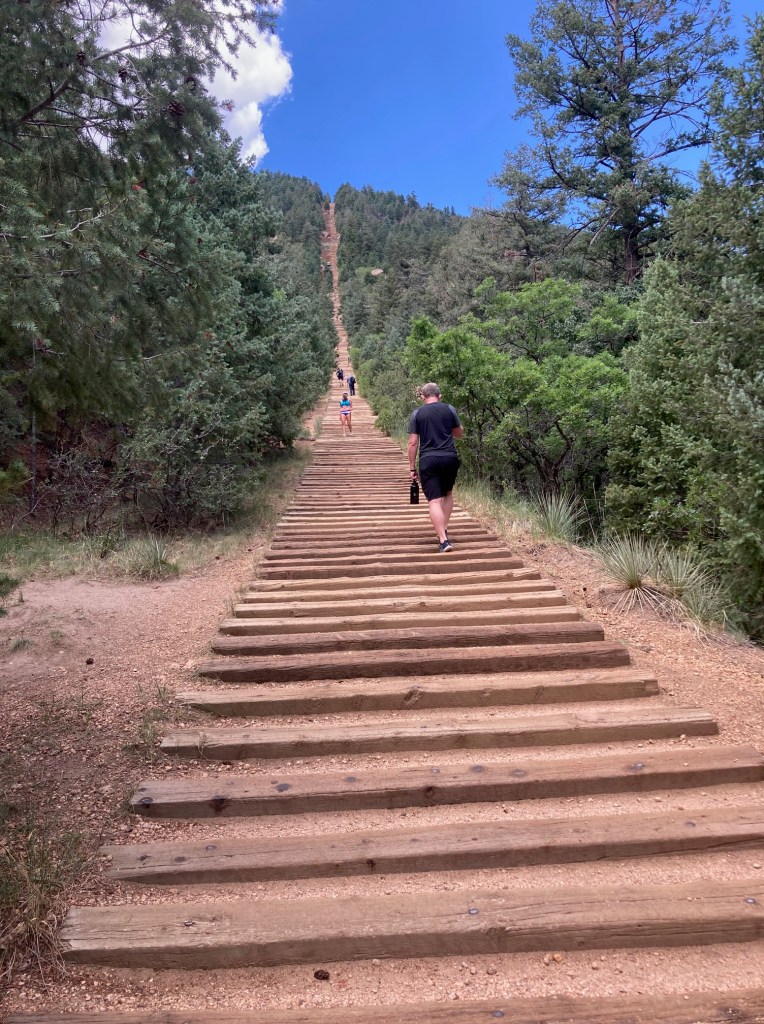
We left the kids at the camper because they had zero interest in torturing themselves that day. We checked in at the check in station (they only allow so many hikers per hour for safety reasons), and started the long walk up the stairs. The first thing you notice, is that the stairs are just railroad ties, as you get steeper on the hill, those railroad ties are held to each other by steel cables.
We started up the path, and we quickly noticed that there was a placard on step 100, well at least we’ll know how far we have to go. It was fairly obvious early that this was going to be more difficult than we expected. When we got there we were thinking it would take an hour to get to the top. By step 200, we were already taking fairly regular breaks, and an hour was out of the question.

Struggling with Thin Air
One of the problems was that the entire time we were in Colorado, Jenn and I seemed to be taking turns having issues with altitude. I was particularly surprised by my issues with the elevation, because I’d been higher before without any issues, and I was having breathing problems trying to sleep at 6,500 ft elevation, which was pretty unexpected for me. I mean I was training for a marathon at the time. On this day, however, I was having no issues and Jenn was struggling. She was light headed and breathing heavy. This was also unexpected, she had been training for a half marathon, and we had already been on some reasonably difficult hikes at higher elevations than this. This was really just bad luck that she was having elevation related issues that day.

We made it to step 500 at a little over a half hour and frankly I was pretty concerned, Jenn was really giving it everything she had, but was still struggling with the elevation, it honestly felt like we weren’t going to finish. I asked her if she wanted to bail out and she told me she was determined to finish. Alright, we’re doing this.
As steps started getting steeper in the middle, Jenn was actually speeding up. She was starting to hit her stride, and we began to care less about the difficulty and started to enjoy the hike. The views were more and more amazing as we were ascending. Our stops felt more like a way to get enjoy the view and less a desperate attempt to catch our breath.
The Friendly Ground Squirrels
On one of our stops, I opened up a Lärabar, and a ground squirrel came up to me. Apparently, these squirrels are super tame and have learned to beg for food. He grabbed it, and quickly gobbled it up. He was obviously very used to hikers and continued to hang around while we caught our breath, even posing for a couple of pictures.

Finishing the Incline
We kept up the path, which in spots were getting steep enough that I needed to use my hands. We went past step 1,500 then 2,000. By the time we were around 2,300 the summit was becoming visible. Just a little further.
We made it all the way to the top, and the view is surreal. There is definitely a reason people are willing to torture themselves to do this. I’ve heard that on a clear day you can see Kansas, and while I don’t doubt that, it’s not like there’s some landmark to look for on the horizon. It was difficult to believe those tiny buildings down below us were from Manitou Springs where we started the hike.

I’m very proud of Jenn for finishing that hike. I knew she was having a bad day and she pushed through. On a different day, she probably would have enjoyed it more and honestly it probably would have taken half the time. She persisted through the light-headedness and shortness of breath.
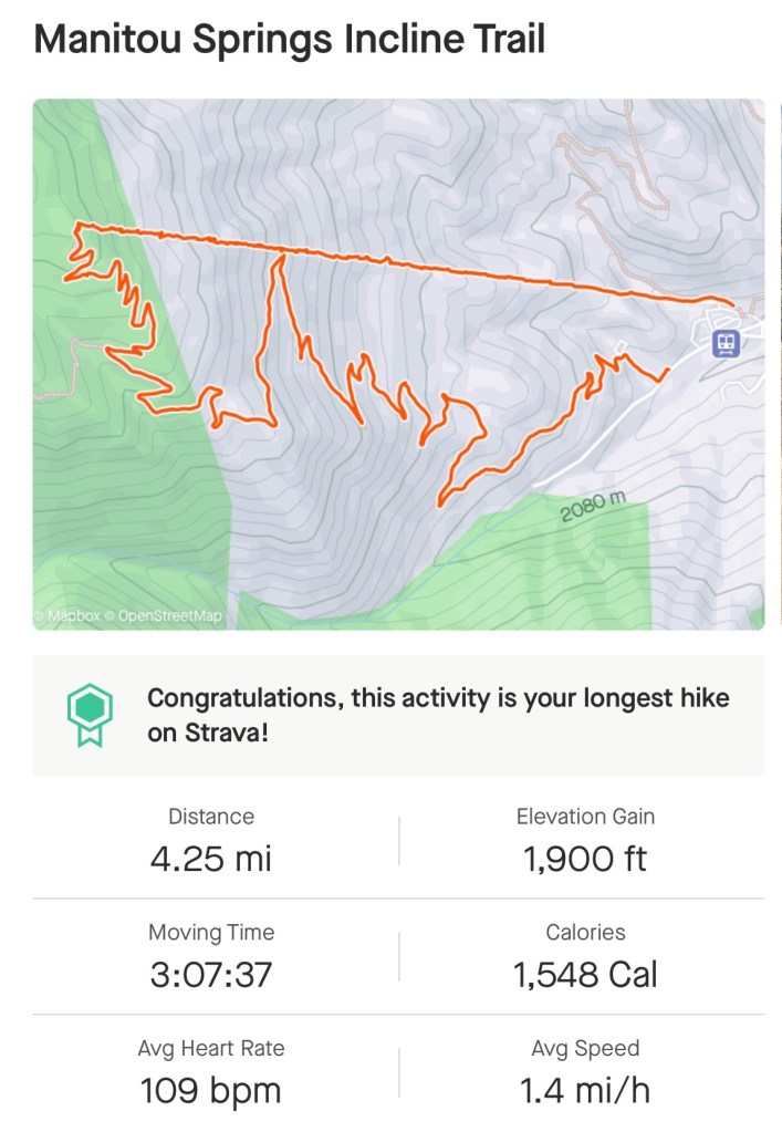
We proceeded down the 3 mile downhill trail to get back to the town and hopefully catch a drink since we had run out of water already. I believe the 4 mile hike took about 3 1/2 hours, which was definitely slower than the average hiker, but I’m okay with just finishing it. It’s a beast.

How do You Make Reservations for the Incline?
Reservations are recommended. If you show up the day and expect to just start hiking, there might not be an available time slot for you. Reservations are free and can be made at the Colorado Springs website.
Capacity from mid March to early November:
- 65 hikers every 30 minutes from 6 AM to 9 AM
- 45 hikers every 30 minutes from 9 AM to 3:30 PM
- 25 hikers every 30 minutes from 3:30 PM to 6:30 PM
Capacity from early November to mid March:
- 25 hikers every 30 minutes from 6 AM to 7 AM
- 45 hikers every 30 minutes from 7 AM to 8 AM
- 65 hikers every 30 minutes from 8 AM to 1 PM
- 45 hikers every 30 minutes from 1 PM to 2 PM
- 25 hikers every 30 minutes from 2 PM to 3 PM
I would recommend taking weather into account when making reservations. For example, during the summer, if the weather is likely to warm and sunny, you might want to start early in the morning when it’s a little cooler, because the heat might zap you of your energy.

How Long Does it Take to do the Manitou Incline?
The length of time it takes to do the Incline varies wildly. It took us around 2 hours and 30 minutes to reach the summit. That is definitely slower than average. The average is probably around 90 minutes. The record was set by Remi Bonnet in 2022. It took him a mindboggling 17 minutes 25 seconds. The record for a female was set by Allie McLaughlin in 2010 in a blistering 20 minutes 7 seconds. There are more Manitou Incline records here.
This is just to get to the top of the incline, there is a much easier 3 mile winding decline back to the parking lot that will probably take the average hiker just short of an hour.
In case you’re curious about how many calories you’ll burn on the Incline, according to Strava, I burned over 1,500. Keep in mind I weigh a little over 200 pounds, so if you weigh less than that, you will burn fewer calories and if you weigh more, you will predictably burn more. I’m sure there’s a good restaurant or two in Manitou Springs to replace those calories after burning them.
Can a Beginner do the Incline?
The Incline is a pretty serious hike. You need to be in pretty good shape to do the incline. Here are a few questions you should ask yourself before you attempt the Incline.
- What overall cardiovascular shape am I in? This does require a decent, but not spectacular amount of cardiovascular health.
- How flexible are I? These are not uniform steps, some are probably about 2 foot high, and while you don’t need to be a gymnast to be able to climb the steps, a decent amount of flexibility is important.
- How acclimated to the elevation are you? If you are not very acclimated to the elevation, you might find yourself fighting for air. In that case, you will probably want to be in really good cardiovascular shape to attempt it. If you are acclimated to the elevation, cardiovascular health will be less important. In other words, a person who lives at elevation in Colorado Springs will probably not need to be in quite as good of cardiovascular health as someone who lives at much lower elevations, like Iowa, for example.
Where Do You Park for the Manitou Incline?
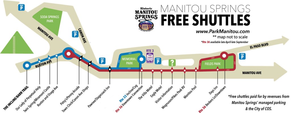
Paid parking is available at the Manitou Hiawatha Gardens parking lot. That shows up as the P icon located to the right of Memorial Park on the map below. As you can see, there is a free shuttle stop there that will take you to the base of the incline. Expect to pay around $2.50 per hour for parking in the Hiawatha Gardens lot.
Manitou Springs uses a kiosk system where you can pay with a credit card using a smart phone. This is really nice, because we were we found ourselves eating lunch after our hike when I received a text message telling me my time was expiring and asking me if I wanted to extend my time. I was able to pay for additional time right from my phone, without having to go back to the lot to extend the time. More information about parking in Manitou Springs can be found here.
What if I Can’t Finish the Incline?
There are plenty of people who don’t make it, so don’t feel too bad about not making it up the Incline, it’s a serious challenge. I saw a number of people who were walking down the stairs, which does get increasingly difficult as you move up the incline and it gets steeper. More importantly there are three bailout points along the path. The first bailout point is at step 395 and the second bailout is at step 1300. Each of these bailout points connects to the Ute Pass which is a gentle decline back to the base of the trail. The third and final bailout point is at step 1800 and ties back to Barr Trail.
There are no bailouts past step 1800, so you should do a real gut check at that point to decide if you can finish. That bailout a little more than halfway to the end and it gets increasingly steep from that point, so the further you get from step 1800 the harder it is to return to the bailout (and the closer you are to finishing).
What should I Wear on the Incline?
When dressing for the incline, you need to realize a few things.
- Dress for the weather – you’ll be out there for a while and there isn’t going to be any air conditioning or heating along the way. You will be exposed to the wind and sun with no shade for most of it.
- We wore running shoes, but it would have been useful to have some shoes with a little more grip. There is a lot of loose sand on the trail and falling is a distinct possibility. Trail shoes are probably more appropriate than running shoes.
- You are going to be taking some big steps and you’re going to want to have clothes that give you freedom of movement. Tight jeans would probably be a poor choice, for example.
- It is helpful for someone in your group to have a backpack so you can store extra water, snacks, and maybe some extra clothes. It also doesn’t hurt to have some a first aid kit and some sunscreen.
Are There Bathrooms on the Manitou Incline?
No, there are no bathrooms on the Incline, so you should take that into account before starting the hike. There are porta-potties near the entrance that you should use before starting the Incline.
So is The Incline Worth it?
Below is a great video made by The Twins Wolfe about the Incline. It gives you a great idea of just how hard but also rewarding this hike can be.
Not Challenging Enough? Keep Going on the Barr Trail to Pike’s Peak
Once you finish the Incline, you will meet up with the Barr Trail, which is the path that goes from Manitou Springs to the top of Pike’s Peak (elevation 14,115’). Most hikers exit the incline by going down the Barr Trail to the beginning but you can use the Incline as a “shortcut” and trade an extra 2 miles of hiking for an intense climb. From there, no big deal, it’s just a little more than 9 miles and 5500 of elevation to Pikes Peak. If you can do that, my hat’s off to you. You’re a certified badass.

Leave a comment